

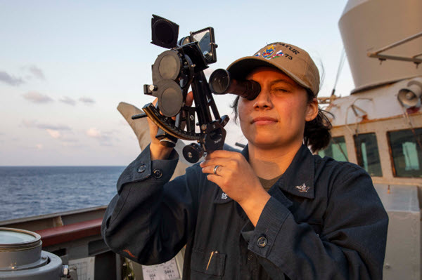
Philippine Sea. (April 10, 2023): For centuries, Sailors struggled to navigate their vessels safety across great oceans relying only on the stars to guide their way. In this photo by MC2 David Negron, Quartermaster 2nd Class Leslie Juarez, from Laredo, Texas, looks through a stadimeter on the bridge aboard the Arleigh Burke-class guided-missile destroyer USS Decatur. A stadimeter is an optical device used to estimate range and distance of an object of known height by measuring the angle between the top and bottom of the object.
Like the Sextant that measures the distance of celestial bodies, the Stadimeter uses mirrors to determine the angle between two objects to measure distances. Using the Stadimeter, Quartermaster 2 Juarez can identify a distant ship, adjust the stadimeter for its mast-head height, and then determine the distance of the object from the ship.
The hand-held Stadimeter was invented in 1890 by U.S. Navy Officer Bradley Allen Fiske who developed the device for gunnery purposes, but also found it proved useful for fleet sailing, especially keeping warships at the proper distance from one another in convoys. It is one of several types of optical rangefinders that do not require a large instrument and so are ideal for hand-held use or they can even be installed in a submarine's periscope.
Of course, today’s mariners are blessed with Global Navigation Satellite Systems (GNSS) to navigate all the world's lakes, seas, and oceans. The GNSS is a constellation of satellites that send signals from space that transmit positioning and timing data to receivers on earth. The receivers then use this data to determine their location, accurately to within 9 feet, anywhere in the world.
Modern maritime GNSS units now include functions inconceivable in the days of sailing ships. In the 1800s, “man overboard” usually was a death sentence for the unfortunate sailor. Today, navigation devices can instantly mark the location where a person has fallen overboard, simplifying rescue efforts. The Navy even has “self-steering” ships using internal plotters to navigate without the aid of humans.
Now, what would ancient mariners think of that?