

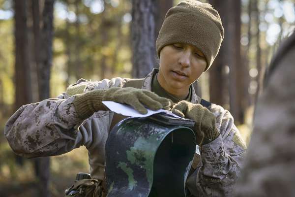
Parris Island, South Carolina. (January 17, 2024). In a previous life, I had the honor to serve as a Primary Leadership Development Instructor, short for the Army’s NCO academy, and my job was to train the next generation of combat leaders. An essential part of the curriculum is the science of map reading and land navigation that every student must master to pass. In this photo Marine Corps Lance Cpl. Ava Alegria, a recruit participates in a land navigation course using the “old fashioned” compass, protractor, and a pencil method.
Today’s young troops, so accustomed to digital technology to solve problems, often find using these unsophisticated methods a bore. Why not just use GPS and not rely on human calculations at all? My response was always, “What happens when the enemy knocks out the satellites?"
This is why the U.S. military continues to teach map reading in this elemental way to prospective infantry leaders. Every infantry leader must be able to identify their position and navigate to various objectives without any electronic assistance. Students begin by understanding how to identify a grid square and to locate a point within it. A grid square is a division of the earth represented on a map on a scale of 1:50,000 (each centimeter is equal to 500 meters on the ground). Locations within this square are referred to as grid coordinates.
Terrain features are displayed using contour lines that identify hills, ridges, valleys, saddles (two small hills sitting side-by-side), and depressions. The closer the contour lines are to one another, the steeper the terrain. The father apart the lines are indicates a flat, sloping terrain. They also learn the colors and symbols used to identify bodies of water or man-made structures like railways or roads.
Teaching these digital natives is no picnic. After a week or two in the woods, two groups would emerge among my students, the City Dwellers, and the Country Boys. The group that presented the fewest problems were the City Dwellers, they knew nothing about forests and clung devotedly to their instruments. The Country Boys, on the other hand, were the exact opposite. Having grown up hunting and exploring in the woods, they scoffed at using a compass or following the proper map reading procedure. They would inevitably charge off into the bush, disregarding proper technique, only to end up hopelessly lost. I swear, most of my time in the field was dedicated to finding these lost lambs who were often miles from where they were supposed to be.
When I asked what they were doing so far from their objective, they would always give the same answer, “We’re backtracking.”
Trust your instruments gentlemen, trust your instruments.
Jim Spearing (SSG-Retired)